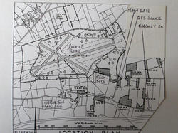
location & layout of airfield.
B.C Form 10/ Lancaster Pilots Notes
576 Sqn Lancaster PD 309 recovery
GROUP CAPTAIN TERENCE JOHN ARBUTHNOT
576 Sqn Wing/Cmdr Basil Arthur Templeman-Rooke
576 Sqn F/O William Carland Johnston
49 Sqn Flt/Lt Victor Medway Arnold
49 Sqn Sgt. E.B.(Ted) Cachart.
49 Sqn Sgt Douglas D.R. Dalaway
576 Sqn Flt/Lt Bertram W. Roberts
576 Sqn Flt/Sgt Johnny Musgrove
576 Sqn Flying Officer Edward L Saslove
49 Sqn Pilot Officer Edgar R. G. Haines D.F.M.
576 Sqn Flying Officer Frank Wilson
576 Sqn Flt/Sgt Dennis Ovenden
49 Sqn Flying Officer Alexander V Bone
576 Sqn Warrant Officer Frederick Taylor, DFM
576 Sqn Warrant Officer Reg Croot
49 Sqn. S/L J.E Raw-Rees D.F.C.
576 Sqn Sgt Alfred Thorpe Turton
576 Sqn Warrant Officer Eugene Patrick (Jimmy) Collins
576 Sqn F/O Archibald de Largy Greig
|
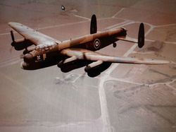
. Lancaster PA474 of the Battle of Britain Memorial Flight flying over Fiskerton Airfield in the 1960's. The control tower complex can be seen under the starboard wing, the technical site under the port wing. |
|
| Location of airfield. Fiskerton airfield is located 4.5 miles east of lincoln and lies between the villages of Reepham and Fiskerton. The Memorials to both 49 and 576 Squadrons are on the left shortly after leaving Reepham and lie at the side of an old runway. The dispersed accommodation sites can be found via a small access road, again on the left and on the outskirts of Fiskerton on the road to Bardney. The Map below shows all the various airfield sites. |
|
|
Plan of airfield This plan is a general overview of Fiskerton airfield. All airfield plans are in two parts. The main airfield is site 1 which shows runways, the perimeter track -which has the dispersal pans for the aircraft around it and the technical site plus the hangers-usually three, which were used for major repairs to aircraft including engine change-outs. Minor work and damage repairs to aircraft were mostly performed at the dispersal points.
The second airfield plan is site 2. This has the dispersed sites such as the accommodation sites, sick bay plus others. On the two plans, all the buildings are numbered and a key lists what they were. These plans are the original drawings to which the airfields were built to. Some airfield plans are still available from Redlion posters and can be purchased if available.
Fiskerton was built to a standard "A" class design. this being the pattern of the three disecting runways. These runways were numbered at each end with the compass headings so pilots knew which runway to approach to land on when returning from a flight. The perimeter track linked the runway ends and aircraft on operations would taxi around in a line to the relevant runway and take off when when given the order to depart. The accommodation sites housed a total of 2,300 persons and each site was numbered. One other site on all wartime airfields was the bomb stores. This was some distance from the airfield and accommodation sites as aircraft trying to land in fog, could and did crash on the bomb stores. Much of the airfield has gone now. Some of the runways and the perimeter track are still present as are some of the dispersals. An outline and location of the airfield can be seen on O.S map number 121 and the airfield lies between the villages of Reepham and Fiskerton.
|
|
|
|
|
|
|
|
|
|
|

